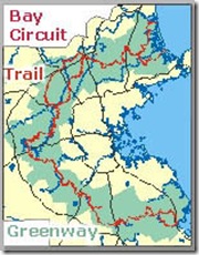
Ok, I’ve lived most of my life in New England. I try to keep up on hiking trail info close by where I live. So, I feel pretty foolish when I come across a site that speaks of the Bay Circuit Trail, or BCT for short. No, I don’t remember hearing or reading about this trail anywhere, that is until today. 
Stretching from the Kingston Bay on the south to Plum Island on the north, the BCT covers 200 miles of trail through 34 towns. How could I have not heard of this? Then again, I did not hear of the wolf sighting & shooting in October of ’08.
Here’s a short excerpt from http://www.baycircuit.org/ :
The Bay Circuit – An Original Bay State Concept: First proposed in 1929 as an outer “emerald necklace,” linking parks, open spaces and waterways from Plum Island to Kingston Bay, the Bay Circuit idea – a precursor of today’s national greenways movement – continues to take shape. Focused on a 200 mile corridor of 50 cities and towns, the Bay Circuit Trail connects the “jewels” of the “emerald necklace.” Community by community, the dream of connecting more than 85 areas of protected land in a greenway around Boston is now becoming a reality.
At present, the entire trail isn’t fully completed, and future meetings in selected towns are scheduled in 2009. Maps & guidebooks can be purchased from the Bay Circuit Alliance in Andover, MA. For more info click here.
Having grown up in this area, and knowing well many of the towns the BCT traverses, I think I know what to expect from walking this trail. Although much of it isn’t difficult or the least bit challenging to someone who really enjoys hiking, still I’m excited to have finally learned about this local trail. Future days will find me scouting out and walking the BCT.
Here are some other links containing good info on the BCT below:
http://www.boston.com/news/local/articles/2009/02/19/bay_circuit_trail_gets_state_boost/
~The Pilgrim.


